Just Another Day of Field Work
Daybreak over the Caribbean Sea. It’s at the peak of hurricane season in the U.S. Virgin Islands, but the sun rose slowly over unusually calm cerulean blue waters as the CrewZen II broke through the glassy surface of the bay. We were transiting out towards our first ground validation site of the day for a new habitat mapping project of the US Caribbean Insular Shelf. Our mission was to drop an HD underwater camera precisely on targets on the seafloor that will verify the benthic habitats predicted by a complex geospatial model over an area about 700km2 wide.
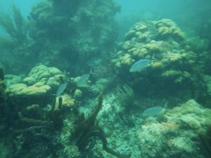
The insular shelf is a broad and moderately deep (30-100m) bank south of St. Thomas and St. John with a steep sloping shelf edge stretching west towards Vieques and the main island of Puerto Rico. This area includes the southern section of Virgin Islands Coral Reef National Monument, which is home to hundreds of species of reef fish, nesting seabirds, and endangered sea turtles. Among the variety of different seafloor habitats are the beautiful coral reefs that can create sanctuaries for schools of fish and invertebrates, as well as expanses of seagrass and soft corals that provide food and oxygen for an abundance of marine life. This area had been mapped extensively for over 12 years by the NOAA Ship Nancy Foster with high resolution multibeam SoNAR, and now it was time to actually see if all of the bathymetry and predictive models were accurate.
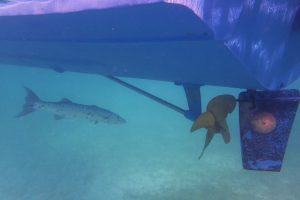
We reached our first ground validation site by following a GPS unit with our preloaded waypoints. Once we arrived to the location, Captain Kevin McCartney pointed the 30-foot boat into the current and threw the engines into neutral as my fellow biogeographer Arliss Winship lowered the weighted camera system overboard. As the camera disappeared into the blue depths, I began recording the video and our location into receivers on board. Soon the seafloor came into view on a small LCD screen and there appeared to be a large dark structure.
As the camera got closer it appeared to be a great aggregate reef, greater than 10m2 and more then 1m of relief off the bottom. There were large healthy colonies of hard plate corals, with long fingerlike octocorals sticking out in between. There were also numerous purple and pink tube sponges and thick leafy mats of macroalgae encrusting the walls of the reef. A small school of barjacks encircled our camera for protection as if it was their bodyguard, a shy little rock hind poked her head out of her coral cave protecting her nest, and overhead a large stalking barracuda lurked under the shadow of our boat, looking for an easy meal. I began to write down my observations on a Trimble Geo Pathfinder and classifying the datapoint for our habitat map. ‘Ok, Pull it up!’ I said to Arliss as I finished logging the data. 1 site down, 49 more to go for the day.
Ground validation using underwater video and photos are essential for the accuracy of mapping benthic habitats. NOAA maps need ‘hard’ evidence and observations from the field that verify the predictions generated by the habitat modeling algorithms that rely on remotely sensed data. These HD videos are not only used to correct inaccuracies in the models, but will also be publicly available once the project is finished for natural resource managers, marine researchers, and for recreational divers to use and enjoy after.
Will Sautter is a marine GIS Analyst for NCCOS, contracted through CSS-Dynamac.