NOAA’s National Centers for Coastal Ocean Science (NCCOS) and Office for Coastal Management (OCM) are pleased to announce two new decision-support products to assist managers in strategic planning for sustainable management of Puerto Rico’s Northeast Marine Corridor. The project team, guided by local partners, have created an online interactive Digital Atlas and an accompanying technical report that describes the online data products.
In Puerto Rico, a new strategic planning initiative will implement a land-sea stewardship process for improved management of the Northeast Marine Corridor. The region has been recognized by NOAA Coral Reef Conservation Program (CRCP), guided by Puerto Rico’s coastal managers and coral reef scientific experts, as one of the most important sites for coral reef conservation in Puerto Rico and in 2015 the region was recognized as a NOAA Habitat Focus Area under the NOAA Habitat Blueprint initiative.
Digital maps are fast becoming an essential strategic tool in the effective management of marine and coastal spaces. In modern marine management, maps are routinely being used to facilitate conversations on spatial planning and for presenting important information such as the locations of areas of special interest (e.g., threatened species habitat, culturally sacred places, economically critical places, or places experiencing conflicting human uses).
At the request of Puerto Rico Department of Natural and Environmental Resources (DNER), NCCOS scientists conducted a spatial characterization of the northeast Puerto Rico region that included biophysical patterns and included human uses. The best available data and local expert knowledge of special ecological places and threats were compiled to map key marine features, important habitat types and marine species of concern. The spatial data supported a ranking of the mapped project area based on known ecological priorities and threats, which will aid managers with risk assessment and management decisions.
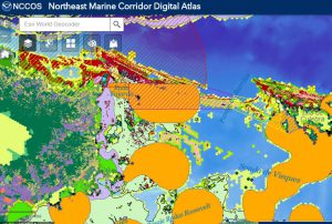
The resulting maps were made easily accessible through a novel online decision support toll called the Digital Atlas for the Northeast Marine Corridor of Puerto Rico allowing local planners, managers, stakeholders, researchers, resource users, and the public to visualize data on the region’s oceanography, seafloor habitats including coral reefs, endangered and threatened species, protected areas, coastal land use and ocean uses.
To describe and explain the data the team provides an accompanying Technical Memorandum titled Mapping Ecological Priorities and Human Impacts to Support Land-Sea Management of Puerto Rico’s Northeast Marine Corridor. The report describes the background to the project area and the methods and sources of data used for spatial prioritization. Maps of ecological priorities and potential ecosystem stressors are presented and the results of an additional Marxan approach to identify priority ocean spaces is also provided in the Appendix.
In addition to providing users with geographically comprehensive spatial information on ecosystems of the Northeast Puerto Rico region, DNER and local planning officials will use the Digital Atlas and the Technical Report to finalize a Strategic Management Plan for the Northeast Marine Corridor. These products will also inform NOAA’s strategic planning efforts for the “Northeast Marine Corridor and the Culebra Island” Habitat Focus Area.
These two products were developed as part of a broader Coral Reef Conservation Program funded project titled “North-East Ecological Corridor Great Reserve Integrated Management Plan”, which was implemented through a partnership between NOAA NCCOS, OCM, and Puerto Rico’s Department of Natural and Environmental Resources (DNER).
For more information on the spatial characterization project, contact Simon.Pittman@noaa.gov.