Coastal Conversations Podcast: Episode 2
In the darkest, deepest zone of the Gulf of Mexico, a vibrant array of corals, fish, sea fans, and more flourishes near the seafloor. Known as “mesophotic and deep benthic communities,” these habitats were significantly injured during the 2010 Deepwater Horizon oil spill. NOAA has conducted offshore expeditions every year since the incident to better understand, assess, and restore these habitats. In this episode, we’ll bring you aboard the NOAA Ship Pisces and chat with NCCOS Knauss Fellow Claire Huang and scientists from Woods Hole Oceanographic Institution, the U.S. Geological Survey, and Geodynamics to learn more about NOAA’s efforts to assess restoration progress for these deep sea habitats.
The Mesophotic and Deep Benthic Communities project is a part of the Deepwater Horizon Natural Resource Damage Assessment and Restoration effort at NOAA. Read about the expedition findings here.
Listen here:
EPISODE TRANSCRIPT

Kevin: Thirteen years ago on April 20th, 2010, an explosion at the Deepwater Horizon oil rig occurred sending shock waves through the Gulf Coast community and crude oil into the Gulf of Mexico. For nearly three months, the wellhead released 134 million gallons of oil – roughly enough to fill 200 Olympic-sized swimming pools. The oil spread and settled down into the deeper parts of the ocean, harming marine ecosystems and habitats in an area about the size of the state of Virginia. The affected areas included sensitive deep-water habitats that receive little to no sunlight from the surface, yet host an abundance of lifeforms like sea stars, fish, crabs, and corals. These habitats, also called mesophotic and deep benthic communities, are vast and complex and form the foundation for the food webs in the Gulf of Mexico. If you visit the Gulf of Mexico these days, the surface may look clear, blue, and teeming with life, but there is still so much we’re learning about these deeper habitats – how can we continue to improve how we’re restoring the diversity and health of the deep Gulf ecosystems damaged by the spill?
[Wave sounds audio]
Welcome, you’re listening to Coastal Conversations, the National Centers for Coastal Ocean Science Podcast, I’m Kevin McMahon. In this episode, we will be learning about a series of annual expeditions that NOAA leads to carry out restoration work, learn more about these hard-to-reach seafloor habitats, and inform future efforts.
The Deepwater Horizon incident was the single largest offshore oil spill in U.S. history and dealt a devastating blow to the Gulf of Mexico’s natural resources and economy. It also required an unprecedented response effort to contain, redirect, disperse, and remove the oil to reduce harm to people and the environment.
NOAA played a crucial role in the response, from dispatching immediate first responders to the site, to designing best practices to minimize harm on wildlife and coastal residents. As part of the Deepwater Horizon Natural Resource Damage Assessment program, NOAA is working with many different partners to plan and implement projects so we can better understand, restore, and protect mesophotic and deep benthic communities injured by the spill.
As part of those projects, at-sea scientific expeditions are the most effective way for NOAA scientists to directly access impacted sites, and to investigate and restore seafloor habitats. Whether it’s mapping rocky bottom habitats or collecting live coral samples, the data gathered during the Deepwater Horizon restoration program’s scientific expeditions will advance restoration in some of the Gulf of Mexico’s most inaccessible yet crucial habitats.
[Wave sounds audio]
This past summer, between June 12 and July 20, 2023, the NOAA Ship Pisces traveled 100 miles offshore from Pascagoula, Mississippi to conduct assessments of these enigmatic ecosystems. The mission was split into three legs, with teams of nearly three dozen NOAA scientists and partners living at sea for 15 to 20 days at a time. While at sea, the mission had a few important objectives. First, in order to assess how healthy deep-sea habitats are looking, we first need to know where they are by mapping the seafloor. Then, once those areas are mapped, scientists identify prominent areas and assess the biology, ecology, and condition of both injured and reference sites.
So, how exactly do you make a map of and study a seafloor that’s 600 meters, or 1900 feet, beneath the ocean? Today’s podcast is co-hosted by Claire Huang, a Sea Grant Knauss Marine Policy Fellow working with NCCOS. Let’s join Claire directly on-board the NOAA Ship Pisces as she leads us through the multiple on-going assessment activities.
Claire went along for the first leg to assist in the operations and coordinate outreach and communications. While onboard, she was able to speak to some of the scientists about the innovative technology that gives us a glimpse into the world of the deep sea. Let’s hear from Claire as she speaks with Morgan Smith, a hydrographer from the Geodynamics Group.
Claire Huang: I’m here with Morgan Smith. Morgan, can you quickly introduce yourself?
Morgan Smith: Yes. Hi everyone, my name is Morgan! I work for Geodynamics and we were invited to come on the Pisces to help with the acquisitions side of this project. So I’m specifically one of the hydrographers on board, and I’ve also been helping with some of the processing on the backend as well.
Kevin: Hydrographers make up an essential part of the ship’s Survey Team, which is in charge of ocean floor mapping. First, we’ll learn a bit about the Gulf of Mexico study sites targeted as priorities for this first mission. Here’s Morgan explaining the uniqueness of the reefs that host mesophotic and deep benthic communities.
Morgan: Specifically these reefs are unique because they’re structurally high in the water column, either sitting atop buried salt diapirs or hard bottoms associated with large relief. We’re primarily working in depths of 150m to 300m so it’s really really cool to be able to see those dynamic changes in these depths.
Kevin: The deep water reef features that Morgan just described are truly dynamic, with fitting names like the Alabama Alps, Pinnacles Trend, and Viosca Knolls. To collect scanned topographic imagery of these seafloor features, the Survey Team uses a valuable piece of equipment called a multibeam echosounder. Here’s Morgan once again explaining how multibeam sonar works.
Morgan: We are using a 2040 Kongsberg Multibeam Echosounder. It’s hull-mounted to the bottom of the boat and basically how it works is it sends multiple sound pulses down in a fan-shaped pattern. The time it takes for those pulses to reflect off the seafloor and return to the receiver is how we measure those depths. After processing, the outcome will consist of a complete coverage, high-resolution bathymetric map of the seafloor. We are able to use that and that will essentially give a good idea of where we want to do AUV and ROV dives in the future.
Kevin: Think of this like creating a satellite Google Maps view of all the ridges, reefs, and other features of the seafloor. Now, you may have just heard Morgan describe two acronyms, “A-U-V” and “R-O-V” doing dives to the seafloor that has been mapped. Those are the names of two other pieces of scientific equipment that help scientists study seafloor habitats that–unless you have a submarine–are too deep for humans to dive to. AUV’s are autonomous underwater vehicles, and ROV’s are remotely operated vehicles. Both of these types of vehicles allow us to zoom in on seafloor features that the multibeam sonar mapped, and take high-resolution images and videos or even physical samples from those areas.
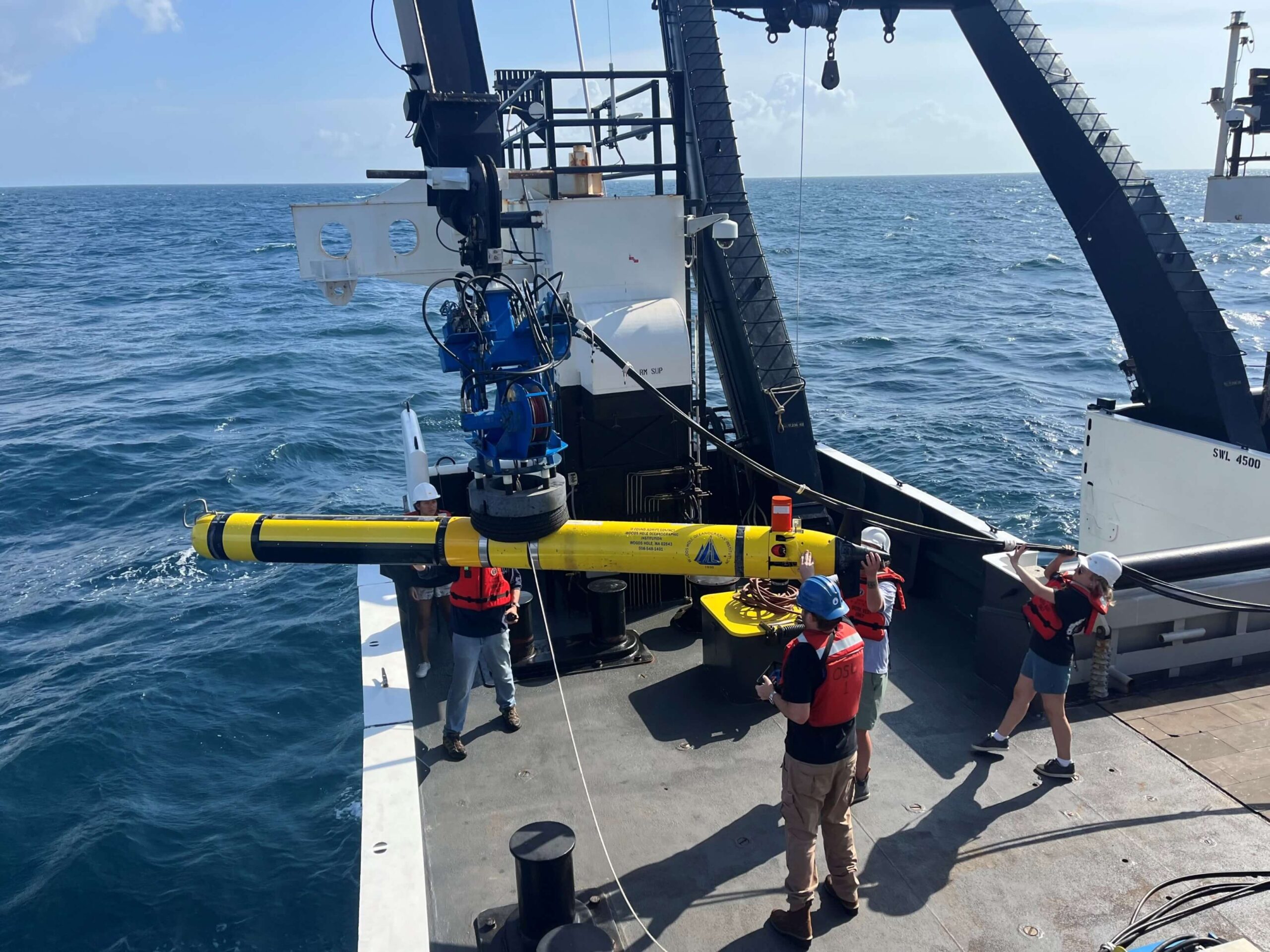
On this leg of the expedition, scientists used an AUV called the Remote Environmental Monitoring UnitS, or REMUS vehicle.These 14 foot long, torpedo-shaped vehicles were initially designed for coastal monitoring but are now used as platforms for a wide variety of instruments at a range of ocean depths. REMUS travel methodically over an area, sort of like a lawnmower, and are particularly well suited for surveying and mapping key ocean characteristics.
Fred Marin: There’s several REMUS’s. In this case, we’re working with the REMUS 600, which is depth-rated to work at a maximum depth of 600 meters. The REMUS is a package vehicle where it has an onboard computer that controls the thrusters and fins and monitors the health of the vehicle. It is battery operated and the scientific payload can be anything. Standard on the REMUS are its thruster, fins, conductivity-temperature-pressure sensor, and there’s an acoustic doppler instrument in the bottom that achieves bottom lock and helps track the vehicle to know where it is in space and time. There’s an inertial navigation unit that drives the vehicle, and it also has its own iridium and Wifi connections and a flashing strobe to help locate the vehicle. Forward of that, that’s in the tail section and in the main body, we can put any kind of payload. In this case, we have a synthetic aperture sonar, which is a side-scan system that maps the seafloor in high-resolution and covers large areas. We’re going to swap that out for a VOYIS system which does bottom imaging and laser line scan, which kind of works like a LIDAR and produces a 3-dimensional, high-resolution image of the seafloor. And that’s just what we’re working on in this case. Typically back home, we find out what kind of sensor we need to achieve the scientists’ goals and we integrate it into the system as a custom fit.
Kevin: That was Fred Marin, a scientist and engineer from the Woods Hole Oceanographic Institution telling us a bit more about how AUV’s work. Hearing the word “autonomous,” you might be wondering the same thing that Claire was thinking:
Claire: So what does it mean that it’s “autonomous,” can it actually self drive?
Fred: We program and give it the mission, which tells it where to go and how to drive, what altitude off the seafloor or depth below surface. It’ll take a GPS fix and then turn on its inertial navigation underwater, it can no longer talk with satellites. It dead reckons or uses transponders to know where its location is. So, we program it, we put it over the side [of the ship], we send it on its way, and it does its own thing, and we monitor it from the surface with acoustic communications. We’ll get modem messages for where the vehicle thinks it is, battery life, pressure, depth, just the essentials. That way we know that it’s doing what it’s supposed to. Then, when it has a problem, we can intercept it and handle those problems.
Kevin: The many unique capabilities of the REMUS that Fred just described make it a perfect tool for NOAA’s mesophotic and deep benthic communities restoration projects. Particularly because the projects involve assessing sensitive coral habitats that may have been injured by the oil spill.
Claire: Are there any pros or cons of using this type of AUV for this current expedition and what we’re trying to do to map the type of habitat that we’re looking at?
Fred: There’s a lot of pros and some cons. We can’t collect physical samples, but as a benefit, we have no impact on the corals. We’re mapping deep water corals in this case and we fly above them and take high resolution images, but we never hit them or interact with them. So, we can survey an area as many times as we want and not negatively impact the site. We can cover very large areas. In this case we’re traveling 3.2 knots underwater. One night we did a 12-hour mission where we covered 80 kilometers of seafloor! So, 3.2 knots sounds slow but over time that adds up! So we’re able to cover large amounts of area and have no negative impact on the environment. We’re also working with an ROV out here with a different group that’s collecting physical samples, but they’re much more localized in terms of how much ground they can cover.
Kevin: The AUV is what scientists call a non-invasive sampling method. NOAA scientists and partners incorporate these innovative science techniques when designing projects to minimize environmental harm while gathering data. The scientists aboard the Pisces also use another powerful non-invasive sampling approach to study the coral, fish, and other biological communities living in the deep. Next we’ll hear from Alexis Weinnig, a post-doctoral scientist from the US Geological Survey.
Alexis: We are sampling water for eDNA, nutrients, and particulate organic matter. Essentially we’re using different particles that are in the water to answer various questions about what organisms might be in the water and what the nutrients and the profile of the water might look like from surface to depth.
Claire: So for folks who might not know how eDNA works, can you just give a little description of how you actually get the eDNA and what you can find out with it?
Alexis: Sure! eDNA stands for environmental DNA and it’s a way of detecting biological life in water or even in soil without actually having to collect the animals. So it’s interesting to be able to filter water for small particles of DNA because it can give us an idea of what’s recently been in the water, or what animals are currently in that portion of the water. We’re able to sample water from the surface all the way down to whatever depth we’re working at. Today, we’re going to be at Viosca Knoll, which is at about 450 meters depth, so we’ll do a couple different sampling points from 2 meters all the way down to 450 meters.
Kevin: As Alexis mentioned, one benefit of using eDNA is that you don’t need to physically see or catch an animal to know it’s present in a habitat – all you need is to collect water samples and detect DNA that it has shed into the water. And everyone sheds DNA, from skin flakes, scales, blood, mucus – even you! This powerful new approach using eDNA will greatly improve our understanding of the health of the affected areas and whether actions being taken now and in the past have had or will be having any effect in remediating the damage from the oil spill. Alexis continues.
Alexis: This expedition is what I call a puzzle piece of the whole project. These are pieces that fit together. On this expedition, we’re able to sample certain sites but on other expeditions throughout this summer and over the numerous years that this project is going on, we’ll sample the same sites but also new sites. It gives us a chance to come back to places and see if the profiles have changed over time, or if they’re staying consistent. It’s nice that this project is as long as it is because we don’t often get the chance to come back to the same sites year after year, and it really provides a temporal profile which we normally don’t have the capacity to do with other projects.
Kevin: NCCOS has been running some monitoring programs for decades. For instance, the National Status and Trends Mussel Watch Project has been monitoring hundreds of static locations nationwide on a regular basis since 1986. Since the oil spill in 2010, monitoring has also been done on a regular basis in the affected areas. By introducing eDNA to this long-term monitoring effort, we open the door to a whole new set of analyses and information about the deep sea ecosystems in the Gulf of Mexico.
Claire: So from year to year, have you seen a change in the diversity of organisms or community structure in these areas?
Alexis: eDNA is pretty new for us! A lot of the work from this project is extending off of work that was done right after Deepwater Horizon and for a couple of years after that. So there are certain parts of this project that they are able to go and perform the same analysis that they did 5 or 10 years ago, and they’re seeing how those communities are changing or what the communities look like now, particularly in sediments. They’re able to go and see how the sediments have changed over time. With eDNA, we’re just starting this part of the project. So we don’t have historical eDNA information and so what we’re also doing last year and this year is creating a baseline of information. “What do the communities look like now, at all these different sites, at these different depths?” So when we continue to do these surveys into the future, we can do that monitoring of how might these communities be changing or what might we be seeing in different seasons or different years.
Kevin: Multiyear sample collection and repeated assessments are crucial across the entire Deepwater Horizon spill restoration effort to help understand both natural recovery processes and how restoration work can help accelerate or enhance them. Let’s circle back to Morgan, the hydrographer, who explains how the multibeam sonar data is used.
Morgan: The multibeam data collected specifically on this cruise will be used to plan future ROV and AUV dive sites to get a better understanding of biodiversity and health of these unique locations. Repeated surveys of the same locations can give us a good understanding of the recovery that this area will have to undergo post-Deepwater Horizon.
Kevin: Together, these three assessment activities, along with the remotely operated vehicle that will be brought onto the Pisces for the next legs of the mission, can give us a deeper look into the recovery and status of the sensitive and biodiverse ecosystems on the seafloor.
[Rice’s Whale vocalizations]
Kevin: That was the vocalization of a Rice’s Whale. It is one of the most endangered whale species in the world. Its population is estimated at fewer than 100 individuals. What little is known about these whales primarily was learned from studies in their core habitat along the northeastern Gulf of Mexico shelf break, the very heart of our study area.
Life on the open seas can be a bit demanding when all of these activities are continuing around the clock in an effort to capitalize on ship time. Setting a daily schedule is an important part of life on deck to ensure smooth operations and the safety of everyone on board. Here’s Claire talking about a typical day on the NOAA Ship Pisces.
Claire: Hey everyone, this is Claire. I’m the Knauss Marine Policy Fellow with NCCOS and thanks for tuning in! So I had the amazing opportunity to join the science team as part of this expedition, and I’m here to share a bit about what our day-to-day life looks like onboard. As you may have heard earlier, the expedition features 3 main activities that include seafloor mapping, water sampling, and habitat imaging using the autonomous vehicle, or the AUV. So, during the day time, the ship is basically moving slowly across the ocean, doing what we call “mowing the lawn.” This is so that the multibeam sonar can sweep through the seafloor and gather data across our study area patches. Throughout the day, folks are usually in the labs, on their computers, working through data that’s been collected the day before, or monitoring the multibeam information. I also help out with CTD casts during the day. That stands for Conductivity, Temperature, and Depth. This is a sensor instrument that collects essentially that type of information. It’s connected to a wire on a crane on the side of the ship, and gets dunked off the side of the ship, collecting live data every second as it descends down to the seafloor. One cool thing that I learned from the Survey Team here on the Pisces is that this is really more of an art than a science. You have to communicate with whoever is operating the crane to know exactly when to stop the CTD so it doesn’t hit the bottom. And it hasn’t happened yet, but we’ve gotten close!
Kevin: Often, the activities throughout the day require an “all hands on deck” approach, especially when handling expensive and sensitive scientific equipment. Claire walks us through the process of how the team works together to deploy the AUV into the water for each dive:
[Radio communications audio]
Claire: Right now it’s 1900 or 7:00pm, and I’m out on the stern of the ship helping our scientists from Woods Hole deploy the autonomous vehicle, also known as the AUV. So Greg and Fred from WHOI have actually installed a special crane head attachment to the crane that’s attached to the ship, so that we can gently lift the AUV from the deck and release it into the water. This whole effort that I’m seeing right now is honestly like a team sport where everyone plays a slightly different but equally important role. So, I’m watching someone steer the crane, someone else is making sure the cables are out of the way, Greg is radioing back to the rest of the crew to make sure that everyone’s in sync. The most important, crucial moment is actually when we send the AUV and lower it into the water from the crane head. That’s when the motors in the machine kick in and it kind of gains a whole life of its own and it starts jumping in the water, wanting to be free and do its dive. So that’s when we, from the deck, have to radio the NOAA corps operations officers on the bridge, and they’re able to gently nudge the ship forward and away from the AUV. That way, the AUV is free to go off and collect data along this pre-programmed dive path.
Kevin: When there is some down time in between each of the scheduled scientific activities, like most of us, the crew looks forward to meal times.
Claire: In between all these exciting science activities, everyone on the ship is sharing meals together in the mess hall. And let me tell you, our steward Ray – Chef Ray – does not come to play when it comes to the kitchen. Every single day, he has put together these amazing, balanced meals. One day it can be grilled veggies and barbeque ribs, and the next day it’s tuna and soup. I’m a huge foodie and I love meal times, but I wanna say on the ship mealtimes are my favorite because I get to catch up with folks I don’t normally get to see during work time. This includes the engineers who are down in the engine room, or the NOAA Corp officers up on the bridge. It’s a really great chance just to get to know each other and catch up on what we’ve been up to during the day. And of course, great food really builds strong morale when you’re out at sea.
Kevin: The NOAA ship Pisces has all the modern conveniences one could hope for especially when you don’t see land for a few weeks. However, that doesn’t mean that working on these expeditions does not come with its own set of challenges. Alexis tells us about some of the unpredictable factors when conducting science offshore.
Alexis: This time we’ve had a pretty smooth cruise, I would say, and we haven’t encountered too many difficult conditions. Just mother nature in general can be challenging. We’re always subject to weather or anything that might not be in our control. So, you have to really be willing to go with the flow no matter what’s happening off-ship in order to accomplish your goals.
Kevin: There are also challenges unique to this deep, offshore region of the Gulf of Mexico that the team must adapt to. Here’s Matt Hughes, a hydrographer with the Geodynamics Group working with Morgan.
Matt: Yeah I think it’s always challenging no matter where you go. This site certainly offers more challenges and different challenges due to the water depths we’re working in. We’re almost in a thousand feet of water. You’re also dealing with commercial traffic from various commercial ventures like oil, gas, different fishing vessels. So we’re trying to juggle between them and coordinate different dive sites at night, along with our mapping during the day at these depths and at various depths. We’ve been going from fairly shallow to pretty much the limit of this currently installed multibeam – that’s certainly a challenge.
Kevin: As Matt and Alexis mentioned, there are some obstacles that the crew and scientists must plan for before setting sail. However, life onboard the Pisces is also fun and rewarding. Right, Alexis?
Alexis: Yeah I do love going to sea! This is I think my 15th expedition, so the more the merrier. I just really like working together, the teamwork that always comes out of every group when you come to sea. Everyone comes with their objectives but you have to work as a team to really accomplish all your different goals. I also just think it’s fun to hang out with people all the time, you get to see everyone’s goofy side because you’re up late or you’re waking up early.
Kevin: Today’s scientists have all returned to their respective laboratories and offices across the country. The daunting task of sifting through and analyzing hundreds of hours of data lies before them. The data and results gathered during this summer’s mission on the Pisces, and all the years before, and all the future expeditions to come, will advance restoration in some of the Gulf of Mexico’s deepest, most diverse, mysterious, and crucial habitats.
Thank you for listening to today’s episode of Coastal Conversations, the National Centers for Coastal Ocean Science Podcast. For more information about NOAA’s projects on mesophotic and deep benthic communities and to see the results of these expeditions, check out the links on the main landing page where you found this podcast. To learn more about NCCOS’s role in this effort or about all the other great coastal ocean science being conducted by NCCOS, please visit our website at www.coastalscience.noaa.gov and search Gulf of Mexico Restoration. Thank you for listening!