Now Hiring: 2 Environmental Scientists, 1 Research Environmental Scientist. Apply here Deadline: July 13.

The U.S. Government is closed. This site will not be updated; however NOAA websites and social media channels necessary to protect lives and property will be maintained. To learn more, visit www.commerce.gov. For the latest forecast and critical weather information, visit www.weather.gov

Our spatial prioritization widget is used to map deep waters around Florida

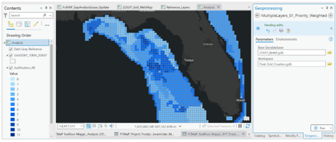
Screen grab of single weighted layer in ArcGIS Pro showing areas deemed important by participants.

Our spatial prioritization widget – a tool used to identify mapping priorities – is being used by partners to determine the implementation of systematic mapping of deep waters around Florida. Learn more: 

https://coastalscience.noaa.gov/news/story-map-on-florida-deep-water-mapping-highlights-nccos-spatial-prioritization-tool/