 An official website of the United States government.
  Official websites use .gov
A .gov website belongs to an official government organization in the United States.
Official websites use .gov
A .gov website belongs to an official government organization in the United States. Secure .gov websites use HTTPS
A lock or https:// means you’ve safely connected to the .gov website. Share sensitive information only on official, secure websites.
Secure .gov websites use HTTPS
A lock or https:// means you’ve safely connected to the .gov website. Share sensitive information only on official, secure websites.Targeted Efforts to Support Nutrient Management
NCCOS supports observations and monitoring for variables that are important to modeling hypoxia in time and space. These models are then used to inform key organizations working to reduce the impacts of ecosystem stressors such as hypoxia. A primary focus of the work is on questions to understand the conditions driving hypoxia in a region and to help resource managers understand the impact of hypoxia on natural resources and the associated nutrient reductions required to reduce any negative impacts. The Hypoxia Task Force (HTF) is a main user of the model forecasts in the Gulf of Mexico.
Gulf of Mexico Hypoxia Task Force Support
NOAA Hypoxia Forecasts
-
- Model Development and Forecasting the Dead Zone in the Gulf of Mexico NCCOS has funded the development of several Gulf of Mexico models evaluating the causes of the Gulf of Mexico dead zone. These models in addition to others developed by EPA have been used to determine the percent reduction in nutrient loads needed to reduce the size of the dead zone to the HTF mitigation goal (5,000 km2). Since 2003, several of these models have forecasted the size of the dead zone in the Northern Gulf of Mexico. This prediction helps managers, policy makers, and the public better understand the relationship between Mississippi River nutrient loading and the magnitude of the dead zone.
-
- NOAA Operation of an Ensemble Model comprised of four models was fully transitioned to NOAA in June 2018. These models allow for assessment of the relationship between nitrogen and the zone size, to inform the nitrogen reduction required to achieve the HTF hypoxic zone reduction goal (outlined in prior bullet).
- Modeling and Forecasting Hypoxia in the rest of U.S. Coastal WatersThe number of areas in coastal waters with dead zones is expanding globally, now over four hundred coastal systems worldwide, including 166 in U.S. waters. A review paper (SCIENCE Aug. 15, 2008) by NCCOS Coastal Hypoxia Research Program (CHRP)-funded researcher Robert Diaz of the Virginia Institute of Marine Science and Rutger Rosenberg of the University of Gothenburg, attributes this dramatic trend to increasing nutrient pollution and the burning of fossil fuels. These trends have continued (Breitburg et al. 2018).NCCOS-funded projects include hypoxia model development for Chesapeake Bay/Delaware Inland Bays, Narragansett Bay, Saginaw Bay, Lake Erie, and Green Bay, and one major watershed hypoxia project for Atlantic and Gulf coast estuaries. The project scientists are working closely with coastal resource managers to cater the model outcomes to information needed for coastal zone and nutrient management decisions. More information on the Coastal Hypoxia Research Program (CHRP).
Hypoxia National Office / Northern Gulf Institute (NGI)
- Measuring the Size of the Dead Zone Since 1985, NOAA has supported an annual monitoring cruise to map the size of the dead zone. Monitoring the size and geographic coordinates of the dead zone provides critical information both for measuring effectiveness of management strategies to reduce it but also as input to models being developed to explain the causes and forecast its dynamics over the course of the season.
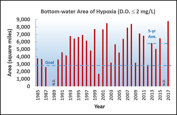
Size of bottom-water hypoxia in mid-summer Data sources: Nancy Rabalais (LSU/LUMCON), and NOAA. Funding sources: NOAA's National Centers for Coastal Ocean Science and U.S. EPA's Gulf of Mexico Program.
-
- Gulf Hypoxia Monitoring Workshop NGI has hosted a series of workshops organizing scientists around better orchestrating monitoring in the gulf region and furthering scientific understanding of the dynamics of the hypoxic zone, as well as the zone’s impacts on ecosystem health and the economy. At the workshops, Gulf Hypoxia Monitoring Stakeholder Committees gathered to coordinate hypoxia monitoring activities to reduce redundancies and increase awareness of the Hypoxia Monitoring. These groups identified both information needs of management, as well as key monitoring and science gaps. Details and library of presentations and meeting proceedings documents can be found here.
- The Cooperative Hypoxia Assessment and Monitoring Program CHAMP is a grass roots effort that emerged from a Gulf-wide recognized need for improved hypoxia monitoring. Gulf researchers, federal and state managers, and stakeholders met at the 6th Annual NOAA/NGI Hypoxia Research Coordination Workshop in Stennis, MS on Sept. 12-13, 2016 to develop a robust and sustainable hypoxia monitoring program to fill this need. Monitoring requirements associated with the CHAMP program are based on four core principles - management drivers, broad community participation, partners with multiple interests, and diversifying financial support. Subsequently eight monitoring workgroups formed representing different regions, focal areas, and management concerns Dedicated to constructing building blocks for CHAMP (see figure below) and now some 60+ members strong and growing, the workgroups are integrating important assets for a Gulf-wide water quality-monitoring program encompassing hypoxia.
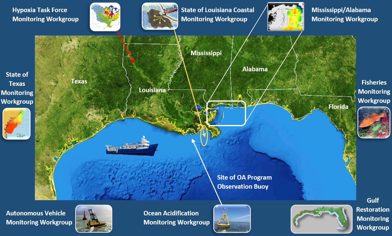
The eight workgroups of the Cooperative Hypoxia Assessment and Monitoring Program (CHAMP) in Northern Gulf of Mexico. Descriptions of the workgroups goals, activities, and ongoing accomplishments can be found here.