 An official website of the United States government.
  Official websites use .gov
A .gov website belongs to an official government organization in the United States.
Official websites use .gov
A .gov website belongs to an official government organization in the United States. Secure .gov websites use HTTPS
A lock or https:// means you’ve safely connected to the .gov website. Share sensitive information only on official, secure websites.
Secure .gov websites use HTTPS
A lock or https:// means you’ve safely connected to the .gov website. Share sensitive information only on official, secure websites.Harmful Algal Bloom Monitoring System
Cyanobacteria Algal Bloom from Satellite in Albemarle and Pamlico Sounds, NC
Images last updated: 04/24/2024
Click the next and previous arrows to view the most recent 12 usable images from the last 14 days.
(You may need to refresh your browser or clear your browsing data to see the latest forecast.)
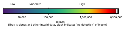
Image credit: The images were derived from Copernicus Sentinel-3 satellite data from the European Organisation for the Exploitation of Meteorological Satellites (EUMETSAT) and were processed by NOAA, National Centers for Coastal Ocean Science.
NOTE: Image quality will vary with clouds and satellite position (OLCI satellite background information). See more information about our bloom monitoring imagery.