 An official website of the United States government.
  Official websites use .gov
A .gov website belongs to an official government organization in the United States.
Official websites use .gov
A .gov website belongs to an official government organization in the United States. Secure .gov websites use HTTPS
A lock or https:// means you’ve safely connected to the .gov website. Share sensitive information only on official, secure websites.
Secure .gov websites use HTTPS
A lock or https:// means you’ve safely connected to the .gov website. Share sensitive information only on official, secure websites.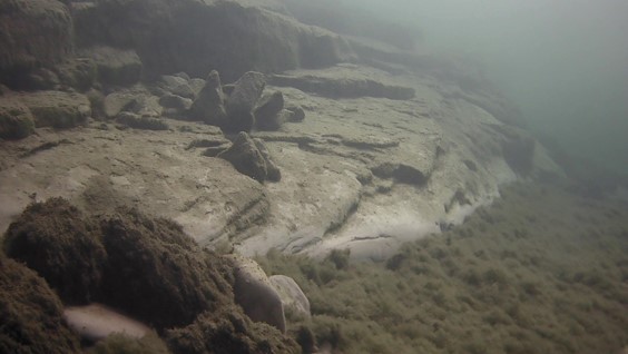
A clay outcrop rises from the bottom of Lake Michigan offshore of Manitowoc, WI. This photo was taken by a drop camera. Credit: NCCOS.
We worked with NOAA’s Office of National Marine Sanctuaries and local partners to map and assess important lake resources in Lake Michigan offshore of Wisconsin.
Why We Care
The area where we are worked was proposed by the state of Wisconsin in 2014 as a national marine sanctuary with the goal of conserving a nationally significant collection of shipwrecks and other underwater cultural resources. These cultural resources are part of a broader interconnected lake ecosystem. This project collected and assessed key ecological information, to map how lake resources are interconnected, and support monitoring, protection and management of ecological and cultural resources.
Data and assessments from this project supported the designation of the Wisconsin Shipwreck Coast National Marine Sanctuary. In addition, the maps and assessments will benefit a variety of other planners and policy makers such as the Wisconsin Historical Society, Wisconsin Department of Natural Resources and US Army Corps of Engineers.

Bathymetric model of clay outcrops on the lakebed off Wisconsin in Lake Michigan. Model by NOAA Biogeography Branch.
What We Did
- We collected new side-scan and multibeam mapping data off Manitowoc and Sheboygan, Wisconsin. These data were interpreted to map important
lakebed habitats, substrates, invasive mussels and nuisance algae. These data are also being used to update nautical charts, and improve our understanding of lake habitats and underwater cultural resources. - We gathered lakebed mapping priorities from researchers and managers spanning a diversity of fields to prioritize future mapping and promote collaboration.
- We compiled and interpreted existing information on water quality, invasive mussels, fish, and lake ice within the boundaries of the proposed sanctuary to support lake resource conservation.
- We partnered with NOAA’s Office of National Marine Sanctuaries, NOAA’s Great Lakes Environmental Research Laboratory, the Wisconsin Historical Society, Wisconsin Sea Grant, the University of Wisconsin and other local partners to build on previous research, leverage lake mapping resources, and discover the region’s data gaps and management needs.
- We are developing online tools and archiving data for policy makers, managers and researchers to explore and use new lakebed maps and other data.
Benefits/Impact of Our Work
Data generated from this study are the first of its kind in Lake Michigan offshore of Wisconsin. The data highlights the unique natural setting found in the underwater environment out of reach to many people. Our maps and data will help coastal managers make more informed decisions, and support future research on invasive mussels, nuisance algae, fish habitats and additional lakebed mapping.
Next Steps
There are no plans to continue this study after April 2019. The lessons learned from this study will benefit other mapping efforts in the Great Lakes.