 An official website of the United States government.
  Official websites use .gov
A .gov website belongs to an official government organization in the United States.
Official websites use .gov
A .gov website belongs to an official government organization in the United States. Secure .gov websites use HTTPS
A lock or https:// means you’ve safely connected to the .gov website. Share sensitive information only on official, secure websites.
Secure .gov websites use HTTPS
A lock or https:// means you’ve safely connected to the .gov website. Share sensitive information only on official, secure websites.In support of the Bureau of Ocean Energy Management, NCCOS characterized seafloor habitats and fish distributions in coastal waters of New York. The New York Wind Energy Area (79,350 acres), located south of Long Island, was leased to Statoil North America on December 16, 2016 for commercial wind energy development. This initiative furthers the New York State objective to provide 50% of its electricity from renewable energy by 2030, and to develop a comprehensive Offshore Wind Master Plan.
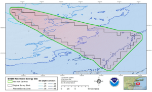
Study Area: The New York Wind Energy Area, also known as the New York Call Area, south of Long Island, about 13 miles off Rockaway Peninsula. Credit: NOAA
Why We Care
The Bureau of Ocean Energy Management issues leases, easements and rights-of-way on the Atlantic Outer Continental Shelf (OCS) for activities that produce or support production, transportation or transmission of energy from renewable energy sources. Prior to BOEM approval of siting a facility, structure, or cable proposed for a renewable energy project on the OCS, an applicant must submit a plan which includes the results of its site characterization and supporting data. In order for BOEM to evaluate impacts to biological, social, physical and economic resources, sufficient baseline information on the area of potential effect of the proposed activity is required. BOEM uses the results of site characterization studies, which include data collection and mapping of geophysical features on the seafloor, to evaluate the potential effect of proposed activities.
In 2011 BOEM received an unsolicited request for a commercial lease from the NY Power Authority (NYPA) that proposed an offshore wind power project south of Long Island, approximately 13 miles off Rockaway Peninsula. Subsequently, BOEM determined that competitive interest in the area proposed by NYPA (hereafter referred to in this document as the “NY Call Area”) exists and initiated the competitive leasing process. A complete summary of the timeline and current status of this project can be found here.
There have been several recent efforts to better describe the ocean floor offshore NY. For example, as part of the NY Department of State’s renewable energy planning efforts and its Offshore Atlantic Ocean Study, released in July 2013, NOAA’s National Centers for Coastal Ocean Science (NCCOS) developed a biogeographic assessment with maps and spatial information on bathymetry, surficial sediments, deep sea corals, oceanographic habitat variables, and seabirds offshore of New York.
What We Did
NCCOS collaborated with BOEM on this effort by providing technical services and expertise to produce a site characterization of the New York Wind Energy Area to include comprehensive seafloor habitat and substrate maps.
Overall objectives of this project included:
• Helping fulfill the BOEM mission to ascertain the environmental impacts on the marine and coastal environments of the OCS and the coastal areas which may be affected by energy development;
• Providing information to be used in environmental impact statements and environmental assessments under the National Environmental Policy Act (NEPA).
• Providing information to manage the development of renewable energy in the Atlantic Outer Continental Shelf.
• Providing NOAA the opportunity to obtain baseline seafloor data and groundtruth the predictive seafloor substrate and sediment models developed by NOAA for the Mid-Atlantic Region.
Specific project objectives included:
• Collecting data on seafloor characteristics by using acoustic sonar surveys, sediment grabs, and underwater imagery to characterize the substrate composition in the New York Wind Energy Area and vicinity.
• Incorporating results of the seafloor data collection into regional predictive models.
• Mapping the seafloor habitat and other important biological and geological observations.
• Characterizing the abundance and distribution of fish in the study area using fishery acoustics.
Through this project, we propose to improve the performance of the regional high-resolution predictions (Poti et al. 2012) of grain size, surficial sediment composition, and hard bottom occurrence. The site-specific work to be conducted within the New York Wind Energy Area combined with the regional prediction models will provide valuable localized information for evaluating the potential impacts of offshore wind development and also identify potential, additional wind energy sites in the region.
Project products include: sediment texture and habitat maps, digital data, a final report, and a presentation of the work to BOEM.
Benefits of Our Work
This work will help BOEM evaluate if the proposed NY Call Area can be used for wind farm facilities.