
The Growing Threat to Coastal Salt Marshes
Coastal salt marshes buffer shorelines, filter nutrients, and store carbon, but accelerating sea level rise (SLR) threatens to drown them. Predicting whether marshes will remain in place or migrate inland is important for coastal managers, but these projections can be affected by uncertainty in the data. For example, airborne light detection and ranging (lidar), a common approach used to measure ground elevation, can make marsh surfaces appear higher than they actually are because dense vegetation can interfere with elevation measurements. These errors challenge modelers and decisionmakers, because even small differences in elevation can affect how often a marsh floods, fundamentally shifting model projections of marsh survival.
SLAMM Modeling and Uncertainty Integration

A new study published in Estuaries and Coasts addresses this challenge in Massachusetts’ Plum Island Estuary. Researchers used nearly 3,000 highly accurate field elevation measurements to correct bias in lidar data and generate a range of possible marsh elevations. They combined these elevation estimates with the Sea Level Affecting Marshes Model (SLAMM) and nine possible SLR projections through 2100. By running the model many times with different combinations of elevation and sea-level rise, the researchers were able to see how uncertainty in both factors could change predictions of future marsh conditions and stability.
Introducing the Model-Agnostic ‘Marsh Fate’ Framework
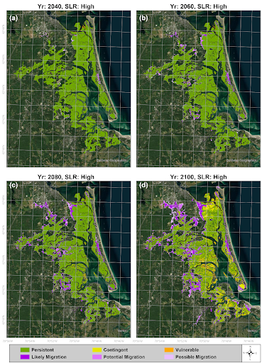
A key part of the study is the “Marsh Fate” classification framework. Rather than delivering complex maps that can be difficult to interpret, the framework groups areas into easier-to-understand categories based on their likely future condition: Persistent Marsh (areas likely to remain stable), Vulnerable Marsh (existing marsh prone to drowning), and Likely Migration Zones (uplands expected to convert to marsh). Crucially, this framework is model-agnostic, meaning the same approach could be applied using other coastal models and in other locations to standardize regional resilience planning.
Key Findings & Decision-Making
The results show that salt marshes respond differently depending on the rates of SLR over time. Under Intermediate SLR scenarios, marsh accretion (or build up) and inland migration help maintain overall platform stability through 2100. Under the High SLR scenario, however, rising water levels eventually outpace the marsh’s ability to build upward, leading to large areas converting to open water later in the century. When the researchers considered uncertainty in both SLR and marsh elevation, projected net marsh area changes by 2100 ranged from a 10.5 percent gain to a 23.2 percent loss.
The Marsh Fate maps turn these model results into information that coastal managers can more easily use. Restoration practitioners and regional planners can directly use the Marsh Fate framework to identify “Vulnerable Marsh” areas to prioritize restoration actions such as thin-layer sediment placement or living shorelines. They could also identify “Likely Migration Zone” areas for strategic land planning, acquisition and protective zoning. By showing both where marshes may be most resilient and where future changes are less certain, the framework can help managers make decisions while accounting for a range of possible future conditions.
This study was supported by the National Oceanic and Atmospheric Administration (NOAA) as well as the U.S. Geological Survey (USGS) Coastal and Marine Hazards and Resources Program and the USGS Ecosystems Mission Area.
Citation: Familkhalili, R., Enwright, N.M., Cosgrove, J.E. et al. Forecasting Marsh Resilience in the Plum Island Estuary: Integrating Uncertainty to Inform Coastal Management. Estuaries and Coasts 49, 197 (2026). https://doi.org/10.1007/s12237-026-01811-5