 An official website of the United States government.
  Official websites use .gov
A .gov website belongs to an official government organization in the United States.
Official websites use .gov
A .gov website belongs to an official government organization in the United States. Secure .gov websites use HTTPS
A lock or https:// means you’ve safely connected to the .gov website. Share sensitive information only on official, secure websites.
Secure .gov websites use HTTPS
A lock or https:// means you’ve safely connected to the .gov website. Share sensitive information only on official, secure websites.In California, domoic acid-producing harmful algal blooms (HABs) of the diatom Pseudo-nitzschiaincreasingly threaten bivalve and crab harvesters, aquaculture, and coastal ecosystems. Using a blend of models and satellite ocean color imagery, NCCOS supported the early development of the California Harmful Algae Risk Mapping (C-HARM) system that predicted the spatial likelihood of Pseudo-nitzchia bloomsand levels of domoic acid (DA); C-HARM still provides monitoring data for skill assessment.
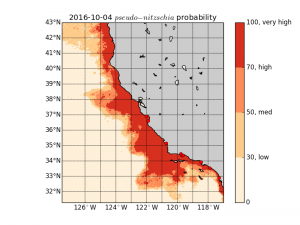
Pseudo-nitzschia (PN) Now-cast for October 4, 2016. The map image displays the probability that the abundance of toxin-producing species of the diatom PN in coastal waters is at or above the 'bloom' threshold of 10,000 cells per liter. A value of 0.7, for example, means there's a 70% predicted probability of PN blooms in that pixel. Credit:NOAA
DAtoxicity threatens human and wildlife health, and is one of the HAB concerns for the coastal region of California. The 2009 West Coast Governors Alliance Harmful Algal Bloom Summit called for predictive capabilities for integrated environmental assessments, early warning systems, action plans, and mitigation strategies and is a major component of the national Ecological Forecasting Roadmap led by NOAA. For example, a model predicting DA events in the waters surrounding offshore aquaculture sites would improve business decisions. Likewise, commercial and recreational shellfisheries managers would better allocate sampling resources to regions with high alert levels, and marine mammal resource managers would use routine model products to guide their efforts and assess likelihoods for animal stranding.
The C-HARM system stems from the NCCOS ECOHAB project comparing coastal HAB 'hot spots' in central and southern California that determines why hot spots exist and how human influences cause blooms, supporting future prediction and mitigation efforts. C-HARM predicts thelocation andcoverageof blooms and dangerous levels of DA using a combination of numerical models, ecological forecast models of Pseudo-nitzchia, sea surface temperature, and ocean satellite ocean color imagery. Scientists routinely run daily predictions (now-cast and forecast maps) at the Central and Northern California Ocean Observing System (CeNCOOS) and post them on its public website.
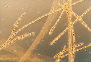
Thesingle-celled, toxic domoic acid-producingdiatom Pseudo-nitschia. Credit: NOAA
A recently completed'skill assessment' of model output for the now-cast data used nearshore data overlappingwith routine pier monitoring of HABs in California. The results, published in the journal Harmful Algae, represent the first year comparing C-HARM model results with actual monitoring data -a fundamental task for initiating a robust early warning system. The model provides information relative with shore station data, but with significant differences requiring continual evaluation and offshore sampling.
The goal is to include C-HARM in the suite of HAB forecasting programs on the verge of transition from research and development to operations such as the Pacific Northwest, Lake Erie, Chesapeake Bay, and the Gulf of Maine. C-HARM is also supported in part by NASA, California Sea Grant, and the Central and Northern California Ocean Observing System.
For more information, contact Quay.Dortch@noaa.gov.