 An official website of the United States government.
  Official websites use .gov
A .gov website belongs to an official government organization in the United States.
Official websites use .gov
A .gov website belongs to an official government organization in the United States. Secure .gov websites use HTTPS
A lock or https:// means you’ve safely connected to the .gov website. Share sensitive information only on official, secure websites.
Secure .gov websites use HTTPS
A lock or https:// means you’ve safely connected to the .gov website. Share sensitive information only on official, secure websites.Staff from NCCOS andthe Channel Islands National Marine Sanctuary have developed aninventory of existing spatial data sets depicting seafloor and habitats off the Southern California Bight to set priorities for future mapping efforts in the region. Last month, the team presented the information at a meeting of state, federal, and academic experts working towardconsensus aboutwhere to focus future data collection in the Southern California Bight.
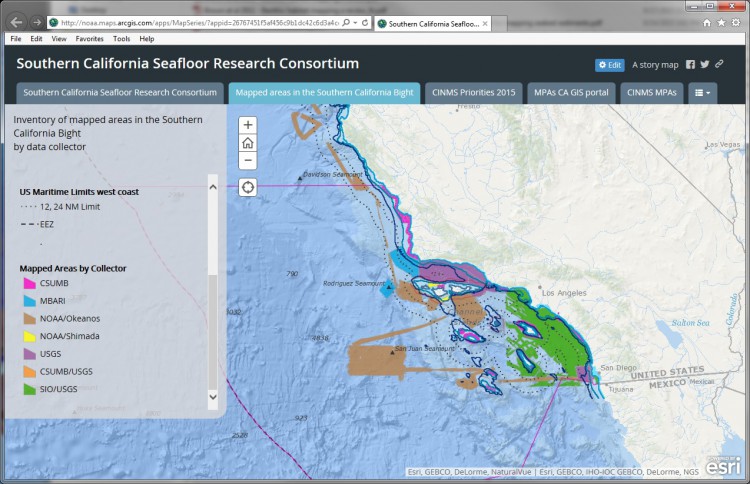
An inventory of existing seafloor data, along with current agency objectives, highlights data gaps that can be filled by new mapping efforts.
Meetingparticipants agreed that seafloor bathymetry and habitat data are critical for a wide range of uses, from resource management to marine spatial planning. Attendees developeda map of priority areas based on the requirements and objectives of their respective organizations, with particular interest in shallow water (less than 30 meters) around the Channels Islands.
The Channel Islands National Marine Sanctuary is a central feature of the Southern California Bight, located at a water convergence zone that supports coral reef ecosystems and is a historically productive area for a diversity of fishes,includingrockfish, anchovy, bonito, and mackerel. However, less than 50 percent of the sanctuary is mapped, making it difficult to know the full extent of marine resources in the sanctuary and how to properly manage them.
For more information, contact Laura.Kracker@noaa.gov.
Agencies represented at the meeting included:
- Channel Islands National Marine Sanctuary
- NOAA's National Centers for Coastal Ocean Science
- California State University -Monterey Bay, Seafloor Mapping Lab
- NOAA's National Marine Fisheries Service
- The Nature Conservancy
- California Department of Fish and Wildlife
- NOAA's National Geodetic Survey
- U.S. Geological Survey
- Ocean Exploration Trust
- Ocean Protection Council
- NOAA's Office of Ocean Exploration
- National Park Service
- University of California Santa Barbara
- Southern California Integrated Ocean Observing System
- Monterey Bay Aquarium Research Institute
- University of California -Santa Barbara
- Bureau of Ocean Energy Management
- U.S. Army Corps of Engineers