 An official website of the United States government.
  Official websites use .gov
A .gov website belongs to an official government organization in the United States.
Official websites use .gov
A .gov website belongs to an official government organization in the United States. Secure .gov websites use HTTPS
A lock or https:// means you’ve safely connected to the .gov website. Share sensitive information only on official, secure websites.
Secure .gov websites use HTTPS
A lock or https:// means you’ve safely connected to the .gov website. Share sensitive information only on official, secure websites.Bathymetric and seafloor information is critical for decision-making in a number of marine management fields, including navigational safety, fisheries, renewable energy, oil and gas extraction, and ecological conservation. Prior to a recent effort to identify information gaps in seafloor mapping data in Southern California, only 13 percent of the regionout to the Exclusive Economic Zone Line had available mapping data. To address this issue, the Channel Islands National Marine Sanctuary (CINMS) and the National Centers for Coastal and Ocean Science (NCCOS) launched the Southern California Seafloor Mapping Initiative in 2014.
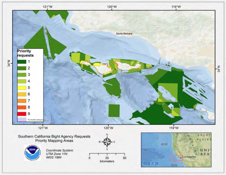
Overlapping agency areas of interest ranked in priority order. The numbers correspond to amount of requests for mapping of that area or co-occurring interests. Credit: NOAA.
CINMS and NCCOS scientists gathered all available seafloor information from California state and federal programs, created a geodatabase, and shared this information via an ArcGIS Online Story Map with stakeholder groups. The team then hosted a one-day workshop with 17 stakeholder groups to identify needs and priority areas for new seafloor data. Some priority areas were common to many stakeholders, includingthe waters ofthe Channel Islands National Marine Sanctuary, existing marine protected areas (MPAs), and potential sites for offshore energy. Spatial overlap of stakeholder priority was highest for CINMS waters as a number of agency stakeholders have jurisdictions and management measures in place around the northern Channel Islands. These areas were shared with the Interagency Working Group on Ocean and Coastal Mapping's Sea Sketch project to help plan future seafloor data acquisitions. The workshop outcomes have already guided NCCOS and CINMS's mapping efforts.
For more information, contact Laura.Kracker@noaa.gov or Tim.Battista@noaa.gov.