 An official website of the United States government.
  Official websites use .gov
A .gov website belongs to an official government organization in the United States.
Official websites use .gov
A .gov website belongs to an official government organization in the United States. Secure .gov websites use HTTPS
A lock or https:// means you’ve safely connected to the .gov website. Share sensitive information only on official, secure websites.
Secure .gov websites use HTTPS
A lock or https:// means you’ve safely connected to the .gov website. Share sensitive information only on official, secure websites.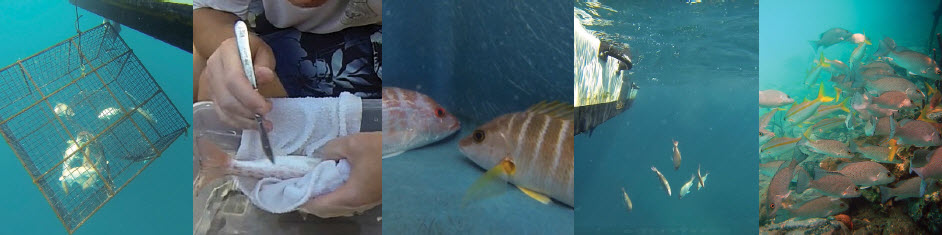
We are monitoring the movement and residence time of fish in several coastal ecosystems. Our objectives are to document habitat preferences of fish, the timing and scales of their mobility, and to establish how habitats are linked through fish movements. Results will help managers understand the effectiveness of marine protected area boundaries and will help guide habitat management decisions such as freshwater flow and coastal development.
Why We Care
Fish play an important economic and cultural role throughout the coastal areas of all US States and Territories. Understanding the habitat preferences and the movement of fish is essential to responsibly manage ecosystems and sustain healthy populations of fish. The need is especially critical in places such as underwater preserves and parks, where the movement of fish can affect park size, boundary decisions, and management approaches.
What We Are Doing
To date, we have deployed an array of underwater hydroacoustic receivers in strategic locations including National Parks, National Marine Sanctuaries, and National Estuarine Research Reserves. We surgically implant transmitters into target fish species and record their movements. We used the data to analyze the sizes of species’ home range, migratory patterns, and habitat preferences.
What We Are Finding
Results from this study indicate that different species of fish use the landscape in different ways and for different reasons. Lane snappers and blue striped grunts, for example, move from reef habitats during daytime hours to offshore seagrass beds at night. Sea bream do the opposite, staying in cover habitat such as mangroves at night, but foraging in sand and seagrass areas during the day. The array of acoustic receivers in each study area is located in both near-shore and cross-shelf locations, providing information on fine- to broad-scale fish movement patterns across habitat types and among management units. Based on fish movement results, we are able to examine the strength of ecological connectivity between management areas and habitats. This information is used to advise managers on topics such as allowable fresh water flow rates, the size of marine protected areas, and the best timing and location of seasonal closures for fisheries species.
Next Steps
Phase I of this project was completed in 2008 along the south coast of St.John, US Virgin Islands. We completed studies in 2012 that focused on the Coral Bay portion of the National Park around St. John. Beginning in 2014, we began investigating fish movements at the nearby island of St. Croix, in the Salt River Bay National Historical Park and Ecological Preserve. We are scheduled to complete that work in 2019. Another study was initiated in SW Florida at Rookery Bay National Estuarine Research Reserve and is anticipated to be completed in 2020. As telemetry equipment becomes available from these various studies, we anticipate additional investigations elsewhere to help managers understand the scale of fish movements and to address local coastal issues.
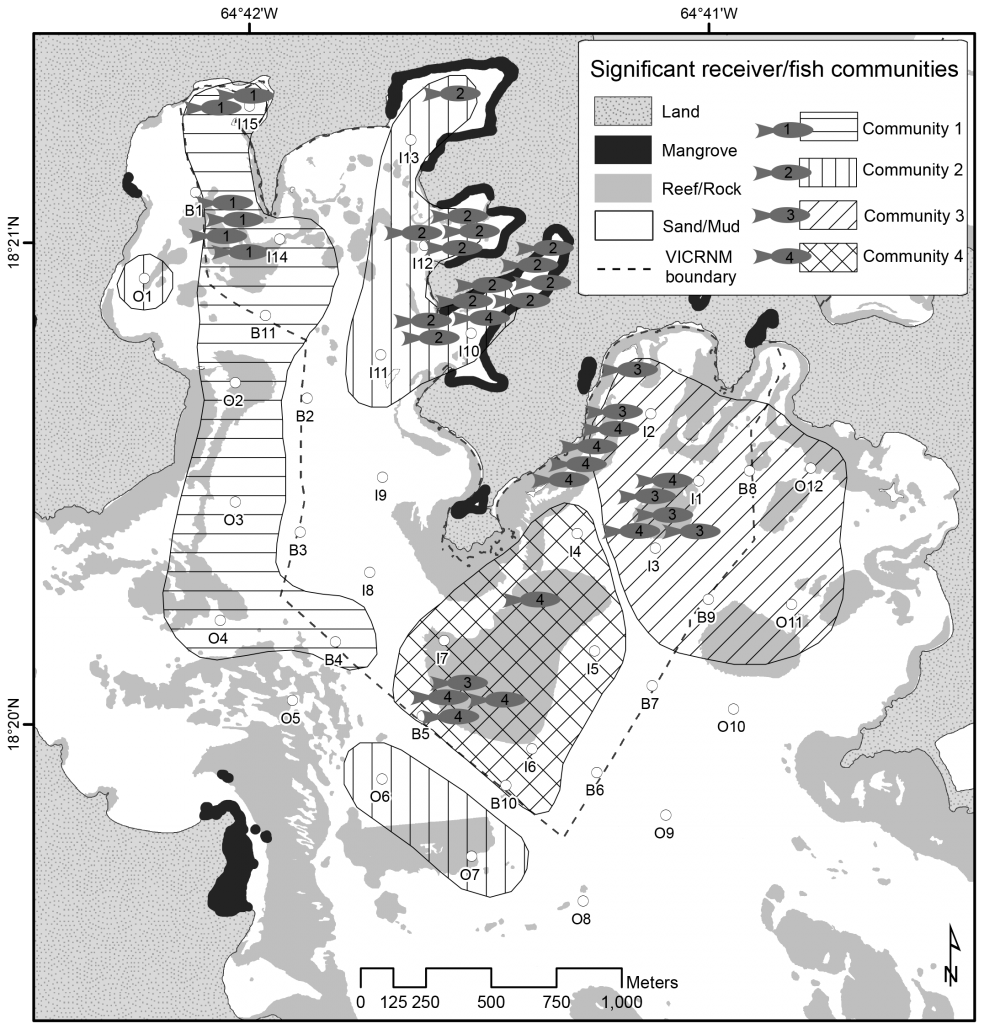
Example telemetry results of how 4 reef fish communities in St. John overlap with marine protected area boundaries. From Kendall et al. Biological Conservation 211 (2017) 37–46.