 An official website of the United States government.
  Official websites use .gov
A .gov website belongs to an official government organization in the United States.
Official websites use .gov
A .gov website belongs to an official government organization in the United States. Secure .gov websites use HTTPS
A lock or https:// means you’ve safely connected to the .gov website. Share sensitive information only on official, secure websites.
Secure .gov websites use HTTPS
A lock or https:// means you’ve safely connected to the .gov website. Share sensitive information only on official, secure websites.NCCOS researchers applied an alternative method to improve classifying and calculatingthe extent of shallow seagrass ecosystems using digital aerial photographs in a recent study. The technique, linear spectral unmixing, is known for its success in classifying other shallow coastal habitats, particularly coral reefs, based on satellite multispectral imagery, but never seagrass. In this instance, aerial photos were used rather than multispectral images, demonstrating that traditional remote sensing techniques involving spectral signatures can be applied to aerial photos having only three bands of spectral information. The unmixing procedure reports the proportion of each habitat-type found in each pixel of an image.

Seagrass habitat in North Carolina ranges from continuous beds, extending hundredsof kilometers (far left) to aggregations of patchy mounds, often less than onemeter in diameter (far right). Here, seagrass spatial configuration results from hydrodynamic stresses, namely tidal current speed and exposure to wind-waves. As hydrodynamic stress increases, seagrass areas become more patchy. Credit: NOAA.
In North Carolina, seagrass ranges from continuous meadows (extending tens of kilometers) to groups of patchy mounds (less than a meter across). To date, the most widely adopted approach to seagrass classification uses on-screen manual delineation of seagrass habitat, which frequently includes areas lacking vegetation within mapped areas classified as seagrass. This leads to overestimates of actual seagrass coverage while ignoring spatial patterns.
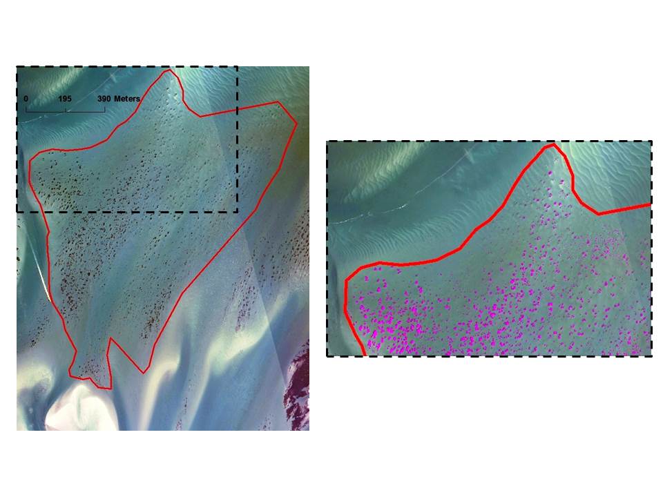
A manually-delineated seagrass polygon (red) encompasses small seagrass patches with extensive unvegetated areas between discrete patches (left). The close-up (right) reveals extensive unvegetated areas between discrete patches and the ability of linear spectral unmixing to classify individual seagrass patches (magenta). Credit: NOAA.
Having a more accurate assessment of seagrass coverage for an area helps fisheries managers to better estimate the extent available to commercially important species, like blue crab and bay scallop. Additionally, classification techniques that better capture seagrass 'patchiness' help address implications of spatial configuration on seagrass resilience in future climate change scenarios and altered hurricane regimes, as patchy seagrass areas are known to be more susceptible to storms than continuous meadows. Linear spectral mixing would improve these abilities by detecting individual pixels where seagrass is present while excluding pixels that are unvegetated. The unmixing technique could be useful in other shallow water benthic systems with highly- contrasted, mixed cover types or sparse cover types.
Preliminary results from this work were presented by NCCOS' Amy Uhrin at the fall 2014 meeting of the Southeastern Estuarine Research Society, held November 6-8 in Carolina Beach, NC. Performance of the unmixing procedure was high with a peak overall accuracy of 98%. At peak accuracy, seagrass classified via unmixing represented only 6.6% of the manually mapped total area. Uhrin received the award for "Best Graduate Student Poster" for her work.
For more information contact Amy.Uhrin@noaa.gov.