 An official website of the United States government.
  Official websites use .gov
A .gov website belongs to an official government organization in the United States.
Official websites use .gov
A .gov website belongs to an official government organization in the United States. Secure .gov websites use HTTPS
A lock or https:// means you’ve safely connected to the .gov website. Share sensitive information only on official, secure websites.
Secure .gov websites use HTTPS
A lock or https:// means you’ve safely connected to the .gov website. Share sensitive information only on official, secure websites.Predicting future patterns of coastal inundation from sea level rise requires knowledge of changes in sea level and changes in elevation of land surface. Surface elevation tables - mechanical devices permanently installed in wetlands - allow scientists to measure small changes in surface elevation precisely and accurately. These devices have been installed in coastal wetlands across the U.S. by a variety of academic, governmental, and private entities, but with little coordination among these groups and no national database of all the surface elevation tables.
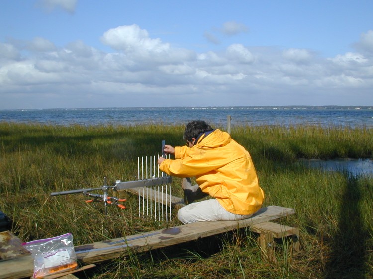
NCCOS researcher using a surface elevation table to monitor elevation changes in a North Carolina salt marsh.
In support of the NOAA Sentinel Site Program - a program designed to address coastal environmental problems, like inundation - NCCOS researchers recently conducted an inventory of all surface elevation tables installed within each of the five NOAA Sentinel Sites (San Francisco Bay, Chesapeake Bay, Central North Carolina, Hawaii, and the Northern Gulf of Mexico). The data collected include the locations of surface elevation tables, as well as information about the ecology and hydrology at each location. These data have been compiled into a single database that can be used to identify gaps in spatial coverage and to facilitate coordinated monitoring efforts. Such coordination will allow for a comprehensive analysis of surface elevation trends in each region. In turn, coastal resource managers can use these regional trends to determine which areas are most vulnerable to sea level rise and to support efforts to predict and mitigate the impacts of climate change on coastal habitats.
A summary report is available on the NOAA Sentinel Site Program website: NOAA Sentinel Site Program - SET Inventory. Also, a related podcast is on the NOS website: Making Waves: Measuring Change in an Estuary.
For more information, contact Carolyn.Currin@noaa.gov.